Thursday, January 27, 2011

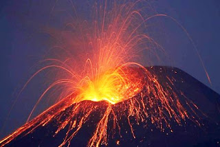
Volcanoes arranged by country and region.

Every volcano which has erupted in the past 10,000 years is listed, plus many ancient volcanoes
  Volcanoes arranged by country and region.
Afghanistan                  Ethiopia
Fiji
France
French Polynesia
Galapagos Islands
Georgia
Germany
Greece
Guatemala
Hawaii
Honduras
Iceland
India
Indian Ocean
Indonesia
Iran
Italy
Japan
Kamchatka
Kenya
Korea
Kurile Islands
Libya
Madagascar
Malaysia
Mali
Mariana Islands
Mexico
Mongolia
Myanmar
New Zealand
Nicaragua

Africa
Alaska
Algeria
Antarctica
Arctic Ocean
Argentina
Armenia
Asia
Atlantic Ocean
Australia
Azerbaijan
Azores
Bolivia
Burma
Cameroon
Canada
Canary Islands
Cape Verde
Caribbean
Chad
Chile
China
Colombia
Comoros
Congo DR
Costa Rica
Djibouti
Dominica
Ecuador
El Salvador
Equatorial Guinea
Eritrea
Niger
Nigeria
Norway
Pacific Ocean
Panama
Papua New Guinea
Peru
Philippines
Portugal
Red Sea
Reunion
Russia
Rwanda
Samoa
Sao Tome
Saudi Arabia
Solomon Islands
South Africa
South Sandwich Islands
Spain
Sudan
Syria
Taiwan
Tanzania
Tonga
Turkey
Uganda
United States
Vanuatu
Vietnam
Wallis and Futuna
Yemen

Volcano Name Location Continuous Eruptions

Volcano Name                         Location                           Continuous Eruptions 

Ambrym                          Vanuatu                                                              1935- 
Tinakula                         Solomon Islands                                                 1951?- 
Erta Ale                         Ethiopia                                                               1967- 
Manam                          Papua New Guinea                                            1974- 
Langila                          Papua New Guinea                                            1960- 
Bagana                         Papua New Guinea                                            1972- 
Semeru                         Indonesia                                                             1967- 
Merapi                          Indonesia                                                              1967- 
Dukono                         Indonesia                                                              1933- 
Sakura-jima                Japan                                                                     1955- 
Suwanose-jima          Japan                                                                     1949- 
Santa Maria              Guatemala                                                              1922- 
Pacaya                     Guatemala                                                               1965- 
Arenal                       Costa Rica                                                              1968- 
Sangay                     Ecuador                                                                   1934- 
Erebus                     Antarctica                                                                 1972- 
Piton de la Fournaise      Reunion                                                          1920- 
Kilauea                      Hawaii                                                                    1983- 

Etna                           Italy                                                                  3500 years 
Stromboli                  Italy                                                                  2000 years
Yasur                        Vanuatu                                                           800 years

Friday, January 21, 2011

BRAZIL,AUSTRALIA FLOOD

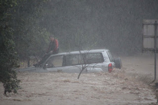
BRISBANE: Heavy rain prompted new flood warnings in Australia even as thousands of volunteers cleaned up the gooey mess coating homes and streets in its third-largest city Saturday.
Four states had flood warnings due to overflowing rivers and rain, while Queensland worked to recover from its deadly, weekslong disaster. Large parts of the vast state are still under water and some places are still on alert for flooding. In Brisbane, the water that swamped entire neighborhoods has mostly receded, leaving behind a thick, putrid sludge.
About 7,000 residents joined 600 military personnel in what was dubbed ‘Salvation Saturday’ to shovel, mop and sweep away the mess after the Brisbane River overflowed earlier this week.
Mayor Campbell Newman praised the overwhelming turnout. ‘Everybody rolls up their sleeves in this town,’ Newman said. The volunteers were given mops, garbage bags and cleaning supplies before being bused to the areas of Brisbane most in need.


Survivors of mudslides that killed more than 555 people are growing frustrated, saying Brazil’s government has fallen short in rescuing victims still stranded on remote hillsides and finding the bodies of the dead.
On the fourth night since torrential rains sent avalanches of mud and boulders smashing through communities in the lush mountains outside Rio de Janeiro, many people were still begging officials for aid late Friday. Many also took it upon themselves to search for their dead and help out the living.
‘The ones I’ve seen go up there and really make the effort are all people from here,’ said Sergio Joaquin de Jesus, 48, a construction worker who had just donated blood and was rounding up a crew of co-workers to dig for bodies Saturday morning. ‘Imagine, human beings up there, with no food, no water, nowhere to sleep, in this weather. They’re living like dogs,’ he said. ‘Where is the government? What are they still waiting for?’
The military said that it was sending 11 helicopters and 500 personnel to help approximately 800 rescuers from fire departments and the state civil defence agency who were struggling to reach stricken areas in an incessant rain. The army and navy also pledged heavy digging machinery, ambulances and generators - the last essential to continue the rescue effort in the dark. Low-hanging rain clouds prevented the helicopters from flying in, however, and the military promised it would try again Saturday. Survivors did what they could.
After failing to find his other children, the 31-year-old ranch hand built a gurney from scrap wood, carried his son’s body down a mudslide-wrecked slope before dawn Friday and buried him in a homemade coffin. Then Perfista waited with a crowd in the rain outside the Teresopolis morgue for a chance to plead with officials to help him continue his search. He clutched plastic-covered pictures of his three other children: a chubby 1-year-old and two smiling girls, ages 6 and 10.
Survivors of mudslides that killed at least 537 people in a mountainous area north of Rio de Janeiro streamed into the centre of Teresopolis on Friday.
Amauri Souza, a 38-year-old who helped Perfista carry his son’s body, said a few helicopters had reached isolated areas, but ‘they’re only taking down the wounded.’ He said officials were not dropping off body bags or food or water, adding that he feared the consequences if aid did not arrive soon.
‘The water is rotten, but people are forced to drink it. There is no food. I had meat in my house, but it’s all gone bad,’ Souza said. Officials fear the death toll could rise once remote areas are reached. Authorities did not offer an estimate on the missing, but local reports put it in the hundreds.
There is no central repository of information about survivors and missing people, said Carla Monica Tomazetto, a city worker using a microphone to call out the names of those being sought by relatives just outside a shelter for those who lost their homes.
Teresopolis, a city of 163,000 people next to a national park, sits in a land of thickly forested slopes and sheer mountain peaks, and is a chief training site for Brazil’s national soccer team. It’s home to many ornate weekend homes where the wealthy of Rio escape the summer heat to enjoy horseback riding and other luxuries.
FLOOD WARNING AND FORECAST ALERT REPORT PAKISTAN 2010

FLOOD FORECAST (ALERT )FOR   SUTLEJ  RIVER

According to present Hydro-Meteorological situation & rains observed in the upper catchment areas of River Sutlej, Ganda Singh Wala (Kasur District) may attain a LOW FLOOD level during the period from 1200 PST of  26th  September-2010 to 1800 PST of 27th September-2010  ranging between 50,000 to 60,000 cusecs (Approximately Gauge 18 – 19 feet ).
This may create inundation in low lying areas of river Sutlej. The inhabitants in the river bed around the districts of Kasur, Okara and Pakpattan may affect. It is requested that concerned authorities may take precautionary measures to warn the people residing in the river bed.
SIGNIFICANT FLOOD FORECAST FOR RIVER INDUS AT KOTRI

According to prevailing hydrological conditions the 2nd Flood wave is passing from Kotri and River is maintaining Exceptionally High Flood level with inflow of 964897 Cusecs. It may further rise during next 36-hours. The sustained peak at Kotri may last for next 2 to 3 days. Thereafter it may start falling and is likely to remain between 7,00,000 to 9,00,000 Cusecs during subsequent 7 to 9 days and around 6,00,000 Cusecs for  subsequent one week.
Under this scenario, the inundation and riverine Flooding is expected at low lying areas of Sajawal, MirpurBataro, MirpurSakro, JhangShahi, AllahRakhio, ShadadKot , Jamshoro, Matiari, Makaro, Ketibander, Shahbander in  Thatta and Hyderabad  Districts  along with the river bed.
All concerned authorities are requested to take precautionary measures to avoid loss of human lives and property. 

Flood Alert for Sutlej  Ravi and Chenab Rivers
       
Sutlej River
 According to Indus Water Treaty, India shall inform Pakistan when the release of water from Ferozepur down stream increases to 50,000 Cusecs or more. India has not yet informed Pakistan regarding the release of such quantity of water from Ferozepur. The slight rise in water at Ganda Singh Wala is only due to rains in the lower catchments of Sutlej below Bhakra dam. As such the water in Sutlej is likely to remain around 50,000 Cusecs in next 2-days.


River Ravi
 The rains in the area below Madhopur headworks and in the Catchment of Nullahs of River Ravi (Deg, Bein, Kethar, Ujh, Basanter) have caused a slight increase in the inflow at Jassar and Shahdara. However, the situation is not dangerous. According to Indus Treaty, India shall inform Pakistan when they release the water from Madhopur headworks more than 30,000 Cusecs and they have not yet informed. Therefore it is presumed that the flow in River Ravi shall remain below low flood level i.e. 40,000 Cusecs.


River Chenab
 The prevailing metrological conditions suggest that the chances of heavy rains in the Catchments of river Chenab are minimum during next 2-days. Therefore there is no imminent danger of any flood in river Chenab. However some rain may cause slightly increased flow in river Chenab, which may not be taken as dangerous situation. The flow shall remain at low flood level (around 1,00,000 Cusecs)

According to prevailing hydrological conditions the Flood wave is passing from Kotri and River has attained Exceptionally High Flood level at Kotri with inflow 8,37,982 Cusecs at 1200 PST. It will continue rising and is likely to attain Flood level ranging between 8,50,000 to 9,00,000 Cusecs during next 24-hours. The River Indus at Kotri shall maintain and sustain peak, which is expected to last 4 to 5 days.
Inflow between 7,00,000 to 8,00,000 Cusecs would last for subsequent 5 to 8 days and around 6,00,000 Cusecs for another subsequent 10 days at least.
Under this scenario, the inundation and riverine Flooding is expected at low lying areas of Sajawal , MirpurBataro, MirpurSakro, JhangShahi ,AllahRakhio, ShadadKot , Jamshoro, Matiari, Makaro, Ketibander, Shahbander in  Thatta and Hyderabad  Districts  along with the river bed.
All concerned authorities are requested to take precautionary measures to avoid loss of human lives and property. 
FLOOD WARNING AND FORECAST ALERT REPORT PAKISTAN 2010


WHAT IS TSUNAMI AND EARTHQUAKE


With a massive 8.8 earthquake striking near Chile and sending a tsunami across the Pacific, Hawaii readies itself for what could be a devastating strike. The island state has a history of being stricken by tsunamis, some generated locally but many from far off areas.
According to the U.S. Geological Survey (USGS), 50 tsunamis have been reported in Hawaii since the early 1800’s. Of those seven caused major damage. Five of those were generated from areas outside the state.


A tsunami is a series of waves that start out as a disturbance under the sea (such as an earthquake), and then increase in intensity. The disturbance causes the waves to travel outward in all directions. In this article, you will learn more about the causes and effects of tsunamis.

The motion of a tsunami is similar to what happens when you toss a rock in a lake and ripples start to form and move about the water. The time it takes for the waves to fully form is between 5 and 90 minutes. Sometimes, the wave speed in the open ocean will average 450 miles per hour.
Tsunamis that have reached a height of more than 100 feet have been recorded. The closer the waves get to reaching shallow coastal waters, the more normal they appear. The speed also decreases. If a tsunami closes in on the coastline, other conditions arise. It may grow in height and when it reaches the shore – it can be highly destructive.
An earthquake is not the only natural occurrence to cause a tsunami. Landslides, volcanic eruptions, and even meteorites have been known to cause an earthquake. A tsunami can start hundreds or even thousands of miles away from coastal areas. Location can play an important role in the effect of a tsunami. The regions at a great risk for suffering a tsunami are found less than 50 feet above sea level and within one mile of the shoreline.
Tsunamis cause a succession of high and low water levels. These kinds of crests and troughs usually occur about 10 to 45 minutes apart.
 The highest death toll from a tsunami happened on December 26, 2004, when an earthquake with a magnitude of 9 occurred under the Indian Ocean. The tsunami struck off the coast of Indonesia with a wave that affected the coastlines of nine different countries about the Indian Ocean. It was estimated in January 20, 2005 that the tsunami took the lives of at least 226,000 people. The total death toll is a number that will never be known.
Other Facts About Tsunamis

A 1964 earthquake in Alaska caused a tsunami with waves that measured between 10 and 20 feet high. The effects of the tsunami were felt along the coasts of California, Oregon, and Washington. In Alaska, more than $84 million in damage was incurred and the tsunami killed 123 people.
Since 1945, more people have lost their lives as a result of tsunamis than as a direct result of what happens with an earthquake.
Tsunamis are rare along the Atlantic coastline. However, a serious earthquake that took place on November 18, 1929 in the Grand Banks of Newfoundland. A tsunami developed and as a result, a great deal of damage and deaths took place at Placentia Bay, Newfoundland.
The most common way that a person dies during a tsunami is by drowning. Other causes of death include flooding, polluted water supplies, and damaged gas lines.
A tsunami that occurred in 1946 sent waves of 20 to 32 feet to crash into Hilo, Hawaii. The downtown part of the city flooded and in the process, 159 people were killed.
An estimate 10,000 people died in Hong Kong when a typhoon accompanied by a tsunami took place in 1906.
The Tsunami Warning Centers in Honolulu, Hawaii, and Palmer, Alaska, keep an eye on the disturbances that can lead to tsunamis. When a tsunami is detected – it is tracked. Tsunami warnings are then issued for areas in danger.


The worst tsunami to strike Hawaii in modern history occurred in 1946 and was caused by an earthquake in the Aleutian Islands. The tsunami struck without warning and claimed the lives of 170 people, mainly near Laupahoehoe and Hilo. Wave heights near Hilo reached 30 feet while the maximum height was 55 feet at the northern tip of the island near the Pololu Valley.

Waves as high as 35 feet struck Hilo, Hawaii and caused 61 deaths and $75 million in damage. Hilo Bay itself was struck the worst where 600 acres of land inland were inundated and only the most reinforced buildings survived. On Maui, the Kahului area was struck the worst where a warehouse and some houses were destroyed.
Tsunamis caused closer to the epicenter of a quake are often more deadly as there is less warning. Two locally generated tsunamis have also caused damage in Hawaii, one in 1868 and another in 1975. The 1868 tsunami destroyed two villages while waves from the 1975 tsunami claimed two lives.

As the wave approaches land, it slows but they increase in height
and the distance between them shrinks. (Wikipedia)A tsunami is typically generated by the movement of tectonic plate boundaries that move abruptly causing an earthquake. As one of the plates moves upward, it pushes the water up and outwards.


Wednesday, January 19, 2011

POWER FULL EARTHQUAKE KARACHI

KARACHI: A powerful earthquake of magnitude 7.2 shook southwestern Pakistan on Wednesday, jolting residents of cities as far apart as New Delhi and Dubai, but doing little damage in the sparsely populated region.
The quake was more than 80 km underground, close to the town of Dalbandin in Balochistan province, near the Afghan and Iranian frontiers, the US Geological Survey (USGS) said.
Akbar Durrani, interior secretary of Balochistan province, said there were no reports of casualties.
“There has been partial damage to house in villages near Dalbandin but there were no casualties,” he told Reuters.
Naeem Shah, head of Dalbandin police, said he had no reports of any injuries or deaths.
“There were no human losses,” Shah said. “The walls of a few houses and offices collapsed but there are no reports of any casualties.”
The USGS said the epicentre of the quake, which struck at 1:23 a.m., was 55 km west of Dalbandin, a town of about 15,000 people, and at a depth of 83 km.
Poor communications delayed reports from the remote area but despite the strength of the shock, its depth seems to have limited damage. The USGS had first said the earthquake was much shallower.
People in India’s northwestern border state of Rajasthan said cracks appeared in the walls of rural dwellings.
US forces in Afghanistan were unaffected by the quake, according to preliminary reports from the US military.
People flee their houses
In Quetta, the capital and largest city in Baluchistan, 330 km northeast of the epicentre, a woman died at a hospital from a heart attack following the quake, hospital officials said.
In the major Pakistani port of Karachi, 400 km away, people rushed from their homes as the quake hit.
“I felt like my bed was shaking. I got up and ran to check the children,” said Masooma Rizvi. “It was very scary. I have never felt anything like this before.”
The Pacific Tsunami Center said the quake had not triggered a tsunami in the Indian Ocean.
A major quake of this magnitude, if at a shallow depth and close to population centres, is capable of causing widespread and heavy damage. Pakistan is still reeling from devastating floods last year that left more than 10 million people homeless.
At least 160 people were killed when a 6.4-magnitude earthquake struck Balochistan, about 60 km north of Quetta, in October 2008.
In 2005, a 7.6 magnitude quake 95 km northeast of Islamabad killed more than 70,000 people.
A 7.7-magnitude earthquake in 1935 hit Quetta, killing between 30,000 and 60,000 people, making it one of the deadliest quakes to hit South Asia in recorded history..

world climate change

NASA’s announcement this year – that 2010 ties 2005 as the warmest year in the 131-year instrumental record – made headlines. But, how much does the ranking of a single year matter? Global temperature records in close agreement, despite subtle differences
Multiple institutions monitor global surface temperatures. Despite subtle differences in the ways the scientists perform their analyses, these four widely referenced records show remarkable agreement. Credit: NASA Earth Observatory
Groups of scientists from several major institutions – NASA’s Goddard Institute for Space Studies (GISS), NOAA's National Climatic Data Center (NCDC), the Japanese Meteorological Agency and the Met Office Hadley Centre in the United Kingdom – tally data collected by temperature monitoring stations spread around the world and make an announcement about whether the previous year was a comparatively warm or cool year. The availability of and access to climate change information remains insufficient, according to many of the world's leading financial institutions. A pioneering study launched  confirms the increasing financial relevance of climate change and the fact that insurers and lenders need better information regarding the physical and economic impacts of the world's changing weather patterns.

Financial service providers and their customers are increasingly affected by the impacts of climate change, such as extreme weather events. Moreover, the survey shows that insurers, reinsurers, lenders, and asset managers expect these kinds of risks to increase in the future.

Given that financial institutions are able to influence their clients and investee companies across all sectors of the economy, they can play a key role in accelerating the implementation of adaptation measures by the private sector.

But in order for the sector to manage climatic risks affecting their business portfolios and to give the best possible advice to their customers, financial institutions need access to applied information such as climate change predictions, modelling, analysis, and interpretation. Such information needs to be appropriate to the duration of contracts, the regions where customers hold assets or undertake operations and the hazards that are material to the operations of borrowers, investees, and the insured.
Not all that much, emphasizes James Hansen, the director of NASA’s Goddard Institute for Space Studies (GISS) in New York City. In the GISS analysis, for example, 2010 differed from 2005 by less than 0.01°C (0.018 °F), a difference so small that the temperatures of these two years are indistinguishable, given the uncertainty of the calculation.

Meanwhile, the third warmest year -- 2009 -- is so close to 1998, 2002, 2003, 2006, and 2007, with the maximum difference between the years being a mere 0.03°C, that all six years are virtually tied.
Even for a near record-breaking year like 2010 the broader context is more important than a single year. “Certainly, it is interesting that 2010 was so warm despite the presence of a La NiƱa and a remarkably inactive sun, two factors that have a cooling influence on the planet, but far more important than any particular year’s ranking .